
On a quiet neatly paved Hoima-Wanseko road, just metres from Waiga Bridge, splendid arrays of savannah grassland and dispersed tropical hardwoods welcome a first time visitor to Kabwola landing site.
It is one of the biodiversity hotspots on the shores of Lake Albert in Buliisa district, Western Uganda.
Along the way, chirps from stridulating crickets fill the airwaves as chameleons, venomous snakes and other wild animals roam lazily among fruit trees and drought hit maize and cassava plantations.
A sweet aroma from smoking fish wafts through the air as other fish species are left simmering in the hot sun.
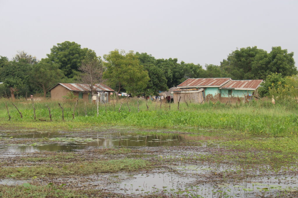
At a distance a monitor lizard dashes at speed to dive into stagnant water near a bushy and abandoned homestead.
The three-bedroomed house nearby has been deserted due to flooding from Lake Albert just like the submerged banana plantation surrounding it.
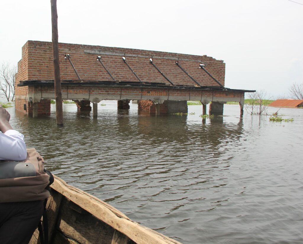
Residents say the house among others in the area were abandoned four years ago when the owners migrated to faraway and safer places such as Biiso trading centre, which is 20 kilometres away, and Hoima city to seek refuge after rising water levels of Lake Albert submerged their houses.
They now live in squalid conditions in congested camps, a phenomenon that has threatened livelihoods and traditions.
Most people were rendered jobless since the lake provides fish, water for domestic consumption and is a source of recreation, all of which came to a halt.
David Barugahara, the Buliisa district Community Development Officer said the floods displaced thousands of people in Butiaba and Kigwera sub-counties and Butiaba town council in Buliisa district.
The most affected people are from Wanseko, Masaka, Katanga landing sites in Kigwera sub-county and Butiaba sub-county villages of Kawaibanda, Boma, Walukuba and Kigangaizi.
The rising waters did not spare schools, roads, and places of worship, health centres, commercial houses and hotels.
Some people came back to resettle in places where water receded as residents had to incur extra costs to repair their houses.
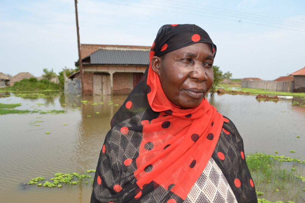
“My house was submerged, crops were destroyed and the water brought in a lot of sandy soils, sand, stones and tree logs,” said Yasmin Majid a mother of four and a resident of Wanseko landing site who has since migrated to Masindi municipality, a neighbouring district.
“But signs are that something may happen soon and the fear is the other time it happened at night and we lost property,” Majid adds.
Behind the flooding
Lake Albert; Uganda’s second largest lake and the seventh largest in Africa on the border between Uganda and the Democratic Republic of Congo, is flooding due to excessive rainfall and adverse effects of environmental destruction, according to experts.
In around mid-2019 to 2020, an event known as Indian Ocean di-pole took place which caused warm waters to brush the adjacent lands to the ocean thereby causing too much rainfall within the Lake Victoria basin.
Flooding from the resultant rains caused the water levels in the lake to rise and flood the areas along the River Nile, the lake’s main outlet that passes through Lake Albert.
Speaking in Lugungu dialect, residents feel the government released water from Lake Victoria, which was full to capacity and that because Buliisa lies in the low lands, Lake Albert ended up flooding.
The lake also receives water from rivers and streams that have too spilled over. Besides flooding, climate change is hitting Buliisa through rising temperatures, heavy rains and violent storms some of which has led to loss of lives in the past.
Experts attribute climate change to global greenhouse gas emissions, which come from burning fossil fuels.
Others accuse the oil sector of releasing water from the ongoing construction of the Central Processing Facility (CPF) at Tilenga oil project in Ngwedo sub-county by French oil firm TotalEnergies which destroyed their livelihoods.
Disrupted livelihoods
By July, flooded areas that had receded were again witnessing rising water levels. “When it floods and residents’ houses get submerged by overflowing Water; water borne diseases such as malaria, dysentery and cholera spread in silence. More poverty and misery is piled on the dwellers,” says Robinah Kimuli, a resident of Kabwola landing site.
Most of the inhabitants in Buliisa which derives its name from Buliisa (grazing land) are Bagungu – a sub-ethnic Bunyoro group – which has lived here on the northeastern shores of Lake Albert, for the past 1,000 years, deriving their livelihoods from fishing and farming, before the discovery of oil in 2006 which has somehow disrupted their livelihoods.
Kwezi Wamara, a fisherman and resident of Ngwedo sub-county, where the oil project is situated, believes that because of the water being too much, fish were forced to move away from the shores into the middle of the lake, which makes it harder for people to catch fish.
Bagungu who speak Rugungu dialect are a product of the intermarriage between the Bantu and the Paluo Nilotics. Historically, they are part of Bunyoro-Kitara Kingdom which is led by Omukama Solomon Gafabusa Iguru.
The 2014 national census by Uganda National Bureau of Statistics indicated that there are 116,000 Bagungu.
The Constitution of the Republic of Uganda 1995 (as amended) recognises the Bagungu as a tribe in Bunyoro.
Recently there have been efforts by some leaders to break away from Bunyoro-Kitara Kingdom and create their own cultural institution called Butebengwa bwa Bugungu (Bugungu kingdom), citing ‘marginalisation’.
They also claim to have cultural heritage different from Bunyoro which must be preserved by the new institution, a thing Bunyoro-Kitara Kingdom refutes.
It was revealed that the neglect to be helped after they suffered devastating floods increased their calls among other concerns to have their own Kingdom.
A resident complained that due to intrusion of new cultures, the traditional methods which Bagungu relied on over the years to conserve the environment under the deep-rooted belief that they are guarded by spirits are waning.
Now, the visibly confused and helpless residents are confronted with a catastrophe that they did not create and from which they are finding it hard to extricate themselves.
Locals further cite charcoal burning, fire woods, cultivation, encroachment on wetlands, lack of proper drainage channels, over fishing which has caused siltation of the lake and an influx of migrants depleting fish stocks, fish breeding grounds and increased land pressure-haphazard settlements as people throng the area in hordes to search for opportunities in the oil sector.
They claim, many people have settled in ecologically sensitive areas once not allowed for settlements. This has increased the risk of climate change linked disasters.
Relying on indigenous knowledge for survival
Steven Birahwa Mukitale, a former Member of Parliament for Buliisa County, said traditionally Bagungu had settlements guided on the basis of clans.
The Kingdom chiefs would show one where to build or cultivate and the last passage of water would be known.
Details about the recent discussion of what “can we do” is something dominating people’s thoughts.

For example, Mukitale says, wherever Saguaro Cacti (Carnegiea gigantean) trees pop up it indicates a dry place and an area where water once flooded and if one was planning to build a home would keep that in mind.
Mukitale recounts memories of how they were told as young boys by folklorists and elders seated around a fireplace of Bagungu’s long history of informing responses to climatic variability and change, at the time of limited access to modern climate and weather forecasts, a thing they termed as inculcating indigenous knowledge to the young.
He said traditionally this would encourage people to develop senses of ownership and active contribution to the sustainability of the future interventions.
Farmers knew the intensity of blowing winds, colour of the clouds, sunshine patterns and plant traits for rainfall prediction.
In 2007, a majority of member states signed a declaration on the rights of indigenous peoples. This recognised that they have the right to the conservation and protection of the environment and their lands or resources.
Mukitale cites corruption for the ubiquitous haphazard building plans since corruption has deep fangs in entities like the district physical planning committees which preside over the planning of settlements.
“It is now easy to build anywhere as long as one is able to pay a bribe. There is need to rid Bugungu of haphazard growth-which in the long run threatens the areas’ sensitive ecosystem.”
Historically, the residents said they heard that similar floods displaced people in the previous years and the people then had learnt how to cope- mainly through gathering information from Banyoro elders who witnessed or heard stories.
In the past, rituals were regularly performed by spiritualists, locally known as Abaramansi, who also grew knowledge from elders to keep a good relationship between the community, the lake and nature.
Many said to their chagrin and the mentality of the youths today, these traditional practices are considered old-fashioned and are no longer performed, alleging that this could be the cause of problems and woes currently being faced.

“Each landing site had spiritualists who performed the rituals and the lake would calm down and eventually give them more fish,” Barugahara added.
Dr. Patrick Byakagaba, a natural resource and environmental governance researcher at Makerere University in Kampala said Buliisa being a flat area, the water table is very low and the soils are sandy.
This causes water to remain on the surface which in terms of ecological landscape makes Bagungu a very vulnerable group, noting that time was ripe to prepare for climate change.
He said to address the situation, the government should avail funds for building the resilience of locals, an infrastructure to prevent disasters and to help those affected.
“Any community that is near a water body will always experience a rise in water levels because of the high temperatures. But also if you look at the landscape of Bugungu, it’s a flood plain, so, it means if you have rainfall due to climate change there will be floods. But the way you tell people to co-exist, counts. They are in the rift valley, they will continue experiencing extreme conditions of rainfall.”
Michael Businge, an environmentalist, said despite persistent socio-economic risks of flooding such as food insecurity and loss of lives, there is still no prioritisation of climate related adaptation, resilience strategies and constant weather forecasts.
There has also been a struggle of smallholder farmers and fishermen who have seen boats capsize and lives lost due to climate related storms and lack of knowledge.
Shortcoming in the shift to modern weather forecasts
Businge says farmers and fishermen need forecasts of modern agricultural methods so that they are not put at a disadvantage compared to areas with quick access to information on weather forecasts.
He said there is a need to shift from reacting to climate related catastrophes to mitigation of impacts by strengthening what works (early warning) and response capabilities.
This, he said, should be in addition to the meteorological information disseminated through the local radios.
Lilian Nkwenge, a Principal Public Relations Officer for Uganda National Meteorological Authority (UNMA) a government agency which forecasts or predicts weather, said they have been issuing out seasonal weather forecasts to enable citizens make informed decisions.
She said they work with districts- departments of production, environment and meet farmers who go back and inform the people.
“We have already issued weather forecasts on all radio stations and newspapers based on what is there and they read out to the public. We give them ten days, monthly and seasonal forecasts,” Nkwenge told The Albertine Journal in a phone interview on May 20.
Barugahara, also a native said in the past when floods were about to strike the area, holders of the knowledge, especially Abaramansi or elders would pass on this knowledge also gained over time and the people would get ready to handle the occurrence, build or shift to safer places.
Barugahara says nonetheless they are becoming more prepared. The district has a disaster management committee headed by the Chief Administrative Officer to keep on updating people with weather forecasts from UNMA.
Barugahara blames people for encroaching on sacred natural sites like wetlands and misuse of the lake.
“That is why we tell people to respect Mpulomas (sacred natural sites) those days Abaramansi (custodians) used to go to these (Mpulumas) and read the weather to signal that something could happen and a sustainable response to the challenge would be found.”
“Buliisa is now cosmopolitan due to oil discovery. It has different communities from north (Alurs) and from Southwestern (Balaalo) and the typical indigenous that moved from the original Buliisa to other areas of Bunyoro,” Byakagaba added.
Bunyoro Kitara-Kingdom advisor on culture, Hajji. Buruhani Kyokuhaire, said this has contributed to uncoordinated settlements exacerbated by high prices of land and intrusion of other cultures that have come and settled anyhow.
He said people are even constructing in water or near the lake unknowingly without approval from the National Environmental Management Authority which must conduct an environmental social impact assessment, adding that when it floods their houses (establishments) get affected.
He blames it on the low mastery of indigenous knowledge practices by younger community members. The other is changing weather patterns challenging community reliance on traditional knowledge for climate change adaptation.
Kyokuhaire urges Bagungu in the absence of accurate weather forecasting infrastructure to return to a time-honoured tradition of using indigenous knowledge to co-exist with the environment.
Researchers take on indigenous knowledge and climate change
In a paper about the role of indigenous knowledge in climate change adaptation in Africa which was published in Environmental Science and Policy of June 6, 2022, the authors’ term indigenous knowledge as important for adaptation decisions to support, disaster management, and forest resource management.
The research done in Eastern and Southern Africa- Uganda inclusive, says indigenous knowledge which is transmitted orally- is also a practiced tradition on conservation of community’s rich ecosystem, knowledge on biodiversity, soil systems and water and climate change adaptation.
The paper said further disruption and dislocation have been caused by the influence of monolithic religion and modern education which have labeled indigenous forecast experts as a witch and traditional practices against the act of God.
The fifth assessment of the IPCC (Inter-Governmental Plan on Climate Change) report also acknowledges that these knowledge systems provide “useful climate change information, observations and solutions” and enable improved adaptation outcomes.
Byakagaba decries limited documentation of this knowledge which makes it hard for communities to cope.
Ageru. A, a researcher in her 2012 paper done in Teso sub-region, said there is need to strengthen dissemination of indigenous knowledge and integration of modern approaches that support indigenous knowledge in climate adaptation and resilience.
Kyokuhaire said Bunyoro lost its cultural identity, norms, names and customs when the cultural institution which was restored by the current government 30 years ago was banned in 1967 by then Ugandan President Dr. Milton Obote.
Countries such as Lesotho, Malawi, Zimbabwe, Nigeria and Zambia, provide a particularly useful model of how a vibrant indigenous knowledge structure can help communities to survive climate change, such as growing drought tolerant and early maturing indigenous crops, gathering wild fruits and vegetables, cultivating wetlands sustainably, and diversifying and selling livestock.
In Ethiopia, pastoralists and agro-pastoralists used the behaviour and activities of biotic and abiotic indicators such as insects, birds, trees and other wildlife, the moon star alignment and animal intestine interpretation to forecast long-term and short-term weather conditions to inform adjustments to farming activities and rangeland management systems.
United Nations High Commission for Refugees (UNHCR), in a 2020 report said a practice has been passed on to the young generation where an indigenous water harvesting technique in the Sahel known as Zai Pits or Tassa helps restore degraded drylands through climate smart agriculture.
The design and positioning of the pits ensures they capture erratic rainfall allowing infiltration of water to irrigate the seeds, which increases soil fertility and crop yields.
Studies emphasise the need for indigenous knowledge to prevent land degradation and biodiversity loss and ensure the sustainability and resilience of ecosystems, coping capacity, forecasts and livelihood options.
Bunyoro Kingdom reinvigorating
Kyokuhaire said the kingdom has strengthened itself by reinvigorating clans to tackle such issues and increased sensitisation of the people, especially migration and co-existence.
He said they have since used every chance to tell the youths to protect sacred natural sites which have been in existence for centuries and are not satanic.
A sacred natural site is a natural feature-large area of land or water having special spiritual significance to people and communities.
The sites include; mountains, hills, forests, groves, trees, rivers, lakes, lagoons, caves, islands and springs for the kingdom’s history dating back centuries but are on the brink of getting obliterated due to developments and degradation.
Robert Rukahemura, a special assistant in charge of culture in the Bunyoro-Kitara Kingdom, Office of the Prime Minister, says the kingdom lacks money to facilitate custodians to maintain these sites, some of which are in derelict state.
This, he said, is an event where the indigenous and local communities are affected by climate change since they rely directly on the environment for basic livelihood needs.
Locals loathe oil production activities
However, locals complain over lack of access to their ancestral grounds and destruction of cultural sites to perform such rituals and protect them as oil firms establish oil production facilities, arguing that some have been fenced off in the due course.
But TotalEnergies has in the past maintained that they follow International Finance Corporation Performance Standards which guarantees and promotes indigenous people’s cultural rights and identity.

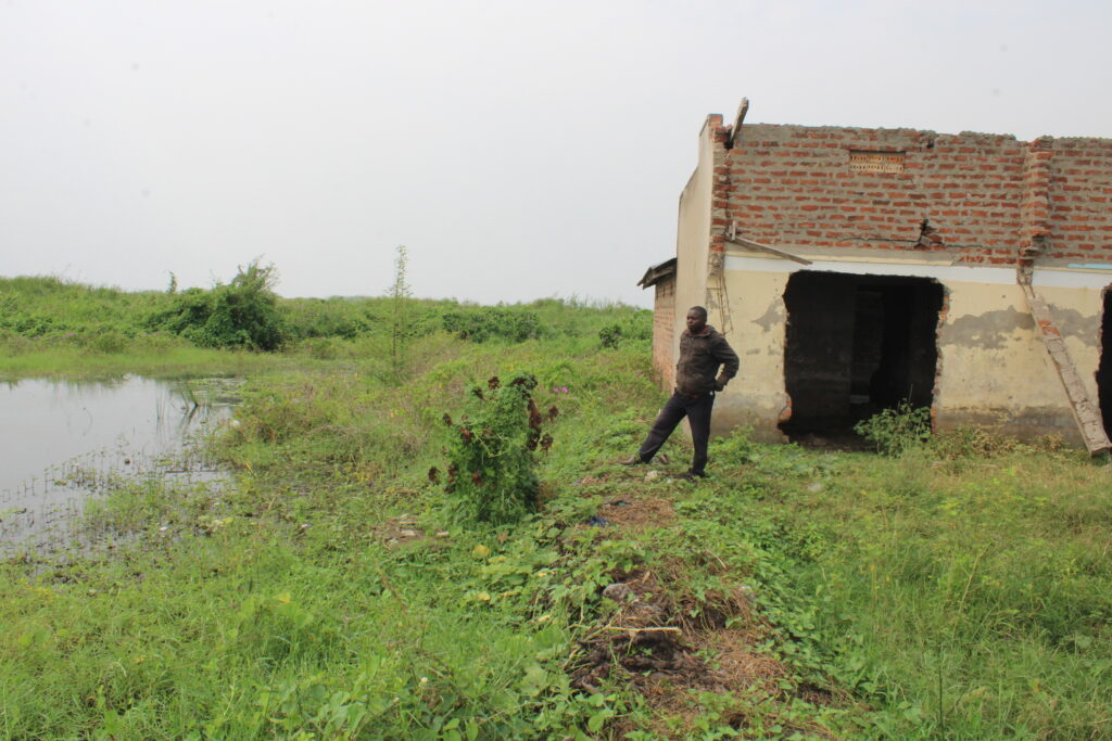
Ronald Mugume, a resident of Butiaba sub-county, accused the ministry of water and environment, the ministry for disaster preparedness for lack of authentic data and a comprehensive study on the ecology of the area.
He said although the former submerged Butiaba Health Centre III was renovated and commissioned recently by the Prime Minister, Robinah Nnabanja, they committed it in error since the place is vulnerable to flooding, questioning why taxpayers money can be wasted like that without a thorough study of the area’s ecology.
Going forward, on December 22, 2020, Buliisa district council passed an ordinance codifying the customary laws of the Bagungu people and protecting the sacred natural sites within Bagungu ancestral territory.
The ordinance deriving from Earth Jurisprudence principles and practice, emphasises use of indigenous knowledge and practices to preserve the eco-system.
It also provides for Abramansi of these sites to keep a balance between human activities, preservation of nature and fostering traditional agro-ecology and traditional seed conservation to ensure food security.
This story was published with the support of a modest stipend from Minority Rights Group International
.
2 Comments
Thanks for this good and informative work
This is good work. The pictures also speak volumes. Keep it up!